Mount Willey - 4,285'
Hike Statistics
Total Distance: 5.4 miles
Elevation Gain: 2,800 feet
Hiking Time: 4 hours, 15 minutes
Difficulty: Moderate
Season: Spring
Hiking this peak in winter? Click here!

Hike date: 06/09/2019
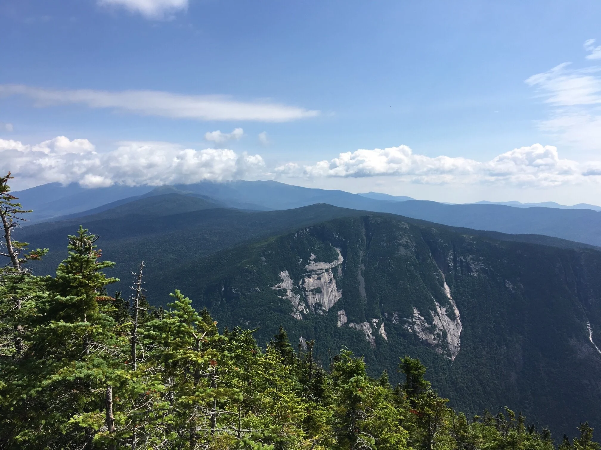
Description: Mount Willey is the second highest and southernmost mountain of the Willey Range, offering nice views of Crawford Notch and the surrounding peaks. Using the below route, you will have the opportunity to make an optional side trip to Ripley Falls and to climb several steep ladders.
Trails Used: Ascend via Ethan Pond Trail to Willey Range Trail to the summit of Mount Willey. Descend by turning around and going back the same way you came.
Trail Summary: The route below is an in-and-out route to the summit of Mount Willey. The trailhead for this hike is at the end of Willey Station Road off of Route 302. It is a short road that leads to a dirt parking lot. As soon as you start out on the trail, you will cross over railroad tracks and ascend on an old logging road. The trail starts out climbing very steadily, but it will then level out and climb more gradually. After hiking for 1.3 miles, you’ll come to the junction with the Kedron Flume Trail. In another 0.3 miles, you’ll come to the junction with the Willey Range Trail. At this point, you will want to get on the Willey Range Trail (by going straight). To this point, you have gained about 1,200 feet in elevation. Once on the Willey Range Trail, you will cross Kedron Brook almost immediately. The trail climbs moderately for now, and you will soon cross another brook. After this, a long, steep, and rough grind up to the summit begins. There are several ladders located along the steepest part of the trail to help you ascend safely, which helps this trail land a spot as an elective on The Terrifying 25 list – more specific details and photos about this portion of the trail can be found here. After the ladders, the trail continues to climb at a steep grade over rough and rocky terrain. Eventually, you will reach the summit cairn for Mount Willey. Right below the summit and before the cairn, there is a side path that leads to a nice outlook point looking east. From the last junction to the summit of Mount Willey, you will have gone 1.1 miles and gained 1,650 feet of elevation. If you are going to include Mount Field and Mount Tom in your hike, you would continue on the Willey Range Trail from here (more on that in the alternative routes section below). Otherwise, after enjoying the summit and hopefully feeding some grey jays (this is a popular peak for that), you will return back the same way you came. The descent is rugged and rough, so some extra caution may be needed on the steeper sections.

Ethan Pond Trail sign before crossing the railroad tracks

Climbing steadily along gravel and loose rocks

Wood steps help make the ascent less rough
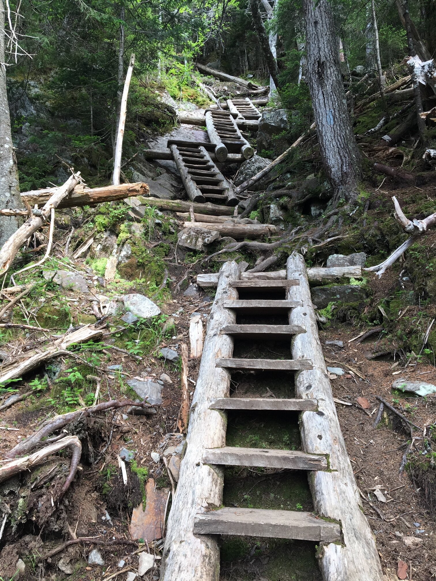
Looking up at the ladder section

Looking down the ladder section; hope you’re not afraid of heights!

Looking south from the summit of Mount Willey down towards Route 302

Enjoying the summit of Mount Willey with views of the Presidentials in the distance
Alternative routes:
One option to get Mount Willey, Field, and Tom is the Willey Range Traverse. This hike starts at Willey Station Road, where you will take Ethan Pond Trail to the Willey Range Trail. Then take the Willey Range Trail to Mount Willey (this involves taking the ladder route - more info here). From Mount Willey, you continue up and over Mount Field. After Mount Field, you will take Willey Range Trail to the A-Z Trail, where you can then take Mount Tom Spur to the summit of Mount Tom. To descend, take the A-Z Trail down to the Avalon Trail to the trailhead at the Depot near the Highland Center. This route will require two cars or hitching a ride at the start/end of your hike. Hike Stats: 8.5 miles — 3,425 feet of elevation gain — Around 6 hours
Another option to get Mount Willey, Field, and Tom is the Willey Range Traverse as an in and out. This is the same as the above route, except after Mount Tom you would retrace your steps all the way back over Mount Willey and back down to your car. This is a long, brutal route, but it is good for people looking for a challenge or those not comfortable hitching a ride / don’t have a second car spot. Hike Stats: 11.2 miles — 4,285 feet of elevation gain — Around 8 hours
Hiking Mount Willey in the winter

We have not yet climbed Mount Willey in the winter, but once we do, we will update this page with our full report!
Questions? Comments? Want to share your take on this hike? Get in touch with us using the contact page!


As experienced hikers, we always make sure that we are hiking with The Ten Essentials which include navigation, a headlamp, sun protection, first aid, a knife, shelter, extra food, water and clothes. Overtime, we have discovered some items that we always bring on our hikes and consider them to be our personal, expanded ten essentials.